Geographic Reference

Mogollon Rim, Arizona

A vast rugged escarpment that stretches over about 200 miles along the southern edge of the Colorado Plateau in east-central Arizona. The Mogollon Rim was named after Juan Ignacio Flores Mogollon, who was the Spanish governor of what is now New Mexico during the years 1712-1715. This southernmost part of the Colorado Plateau forms a definitive separating line between the low-elevation deserts flats surrounding it and the high country of mountains and pine trees above it. The highest points on the rim reach up to 2,000 feet, offering impressive views of the landscapes below.

Gray Streak Mountain, Arizona

Part of the Tunicha Mountains, Gray Streak Mountain is located on the Navajo Nation Reservation in northeastern Arizona, near the small community of Lukachukai. According to Navajo traditional lore the Holy People resided in this mountain before humans were created. The Holy People are spiritual beings who can take the form of landscape features, animals, plants, or celestial bodies and who instruct the community in order to maintain well-being, peace, and harmony. Gray Streak Mountain continues to hold spiritual significance for the Navajo today, and is mentioned in various ceremonies and rituals.

Arctic

The Arctic is the region surrounding the North Pole, which reaches into the northernmost parts of Canada, Alaska, Siberia, and Greenland. The Arctic is characterized by permanently frozen lands, very little vegetation, and extreme changes between summer and winter climate conditions. Although the Arctic is, for the most part, uninhabitable, international economic interests in the region have been increasing in recent decades. These interests are focused mostly on resource extraction, especially petroleum. While rich petroleum deposits in the Arctic offer an attractive solution to the world's unsustainable reliance on oil, the immense cost of drilling in extreme conditions, as well as the high risks of environmental degradation involved, have led to controversies concerning investment in and development of the area.

Colorado Plateau, Arizona, Colorado, New Mexico and Utah

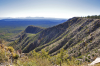
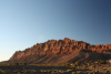
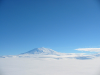
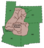
A physiographic province that stretches across 130,000 square miles in the Four Corners Region of the American Southwest. The topographic features of this plateau include: high mountain ranges, deep canyons, river valleys, high plateaus, mesas, deserts, basins, and buttes. The highest elevation in the Colorado Plateau is the La Sal Mountains in Utah at 12,700 feet, and the lowest elevation is the Grand Canyon in Arizona at 2,000 feet. This vast difference in elevation means that the ecology of this landform is varied based on altitude and precipitation, from the alpine tundra of the higher elevations to the riparian areas along the Colorado River. This also means that there is variation in the animal communities based on changes in elevation and vegetation.

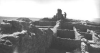
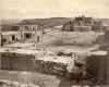
This landscape encompasses portions of two prehistoric cultural areas: the Great Basin and the American Southwest. This area has been continuously occupied since Paleoindian times, with the Clovis culture hunting game as far back as 10,000 B.C. Some of the most well-known structures of the Colorado Plateau are the cliff dwellings found in Mesa Verde, in southwestern Colorado. Around 1150 to 1200 B.C. Ancestral Puebloans began occupying these large alcoves, building stunning dwellings with hundreds of rooms. Around late A.D. 1200 through A.D. 1300 there was a massive migration from the Colorado Plateau south towards the Hopi, Zuni, and the Rio Grande Valleys. It is generally believed that an environmental catastrophe and subsequent collapse of societal organization caused this huge migration. Today, about one third of the Colorado Plateau is Native American reservation land designated to 31 tribes. The tribes that currently occupy the plateau include: Ute Mountain Ute, Southern Ute, various Pueblo groups, Yavapai, Paiute, Apache, Havasupai, and others.

Highway 58, Arizona

In Hillerman's novel The Dark wind, Arizona Highway 58 is mentioned as a connecting route between Winslow, Arizona and the Navajo Reservation to the north. However, the road does not appear on any maps, and there is no indication that it ever did. It is possible that Hillerman got the road numbers mixed up and was in fact referring to either Highway 87 or Road 99, as those are the main routes traveling north from the Winslow area to the Navajo Reservation.

Winslow, Arizona

A small town located just off of Highway 40 in eastern Arizona, about 58 miles east of Flagstaff. The settlement was established in 1880 around a railroad terminal. Its location on the historic Route 66 made it a convenient stop for tourists in the first part of the 20th century, and the La Posada Hotel, which was designed by the famous architect Mary Colter, became a major point of attraction in the area. When railroad travel stopped in the late 1950s, and after Interstate 40 replaced the old Route 66 in the 1970s, the town suffered a devastating economic decline. Today, ongoing preservation efforts make Winslow a destination for nostalgic tourism, which has grown in recent years.

Winslow was made famous in the 1970s when it was mentioned in the hit song "Takin' it Easy" by the American band The Eagles. A statue and mural commemorating the song serve as unique roadside attractions for modern-day travelers visiting Winslow.

Cameron, Arizona

A small community located on the Navajo Nation Reservation in Northern Arizona. Cameron developed around a bridge built by the U.S. government over the Little Colorado River in 1911. A trading post followed in 1916, which offered a meeting place for Navajo and Hopi residents from the surrounding area to engage in the exchange of their wool, crafts, or livestock for dry goods supplied by the trading post's owners. Today, the town has a few stores and restaurants and is a service stop for both locals and tourists traveling to and from the Grand Canyon.

Sichomovi, Arizona

One of the three Hopi villages on First Mesa, which is part of the Hopi Indian Reservation in northeastern Arizona. The village was established in 1750 by members of various Hopi clans from the neighboring settlement of Walpi, and has been occupied continuously since then.

Awatovi, Arizona

An ancient Hopi village, Awatovi's ruins are now a site of archeological research and a National Historic Landmark. The site is located on the Hopi Indian Reservation in northeastern Arizona. The village was a small settlement that was occupied by several Pueblo groups since the 14th century, and was one of the first Hopi villages to be conquered by the Spanish in the 16th century. In 1629, a Catholic mission was built in the village. Despite coerced conversion efforts, the Hopi secretly maintained and practiced their traditional beliefs, language, and rituals. While a small part of the Hopi population accepted Christianity and adapted to European conquest the majority adamantly resisted, holding on to the traditional indigenous lifestyle and belief system. The split led to increasing tensions and violence erupted in 1700 when the traditionalists attacked the mission and the village of Awatovi destroying its buildings, killing many of its residents, and dispersing the survivors among neighboring villages. The site has remained uninhabited ever since.

Hano, Arizona

A small village inhabited by mostly Tewa Pueblo people, located on the Hopi Reservation in northeastern Arizona. The settlement was established around 1700, when the Hopi invited a group from the Tewa Pueblo, in what is now central New Mexico, to help them fight bands of invading Navajo and Ute raiders. The group of Tewa warriors ended up settling atop of First Mesa, one of the three mesas on which the Hopi villages are built. Over the years they have intermarried and mingled regularly with the Hopi, but were never completely absorbed into the tribe, retaining their own distinct language and traditions.

Pages

Subscribe to RSS - Geographic Reference