Geographic Reference

First Mesa, Arizona

The Hopi Indian Reservation, which is located within the boundaries of the Navajo Nation Reservation in Northern Arizona, spreads over three mesas that are part of a much larger rock formation known as Black Mesa. The three mesas, or Hopi regions, are home to the 12 Hopi villages. First Mesa consolidates the oldest Hopi settlement, Walpi (dating back to 900 A.D.), and the later settlements of Sichomovi and Tewa.

Piutki, Arizona

In Tony Hillerman’s novel, The Dark Wind, Piutki appears to be a small community located on the Hopi Indian Reservation in northeastern Arizona. There is, however, no indication that such a place actually exists. It seems that Hillerman used the name of an ancient Hopi village to create a fictional place that would serve the novel's plot without directly referencing a real location, as to avoid infringing on the Hopi people's privacy and traditions.

Navajo Route 13, Arizona

Because Navajo routes are mostly rural dirt roads that are familiar only to local residents living on the Navajo Nation Reservation, it is often hard to determine their exact location. Route 13 appears on maps as a visible road on the central part of the reservation, in northeastern Arizona, but also as a very small road on the Hopi Reservation, which is father west. In Tony Hillerman's novel The Dark Wind, Navajo Route 13 most likely refers to the latter since, in the novel, this small dirt road connects with Arizona Highway 87, which runs through the Hopi Reservation from north to south.

Highway 87, Arizona

Highway 87 crosses the eastern parts of the state of Arizona from north to south. Its northern end connects with Highway 264 at Second Mesa, on the Hopi Indian Reservation.

Abiquiu, New Mexico

A small village in Northern New Mexico, located about 50 miles north of Santa Fe. The area surrounding the village is known for its striking beauty and unique and colorful rock formations. The area has attracted spiritual seekers and artists, most notably Georgia O'Keeffe, who lived and painted in Abiquiu mostly between the years 1929 and 1949.

Chama Valley, New Mexico

The Chama River is a confluence of the Rio Grande, a large river that runs through the state of New Mexico from north to south. The Chama River, and the valley surrounding it, are located in Northern New Mexico near the Colorado border. The area is characterized by its green, mountainous scenery. The Chama Valley was inhabited for centuries by various indigenous peoples, most of whom were nomadic. The most notable of these groups is the Jicarilla Apache, whose reservation lies to the east and the west of the small village of Chama. Today, the Chama Valley remains sparsely inhabited and is a tourist destination for hunters, anglers, and other recreational outdoor enthusiasts.

Chama, New Mexico

A small village in Northern New Mexico named after the Chama River, a confluence of the Rio Grande River that runs through the state from north to south. The area of the Chama Valley was inhabited by various indigenous peoples until the arrival of the Spanish in the late 1500s. The most influential Native group was the Jicarilla Apache, whose reservation currently lies to the east and the west of the town of Chama. The town itself was first established by Spanish colonizers, and later developed around the western terminus of the Cumbers and Toltec Railroad that was in operation between the years 1880 and 1960. The village still retains its rural, historical character, which makes it a unique tourist destination.

Cerrillos, New Mexico

Officially named Los Cerrillos (meaning "The Small Hills" in Spanish), Cerrillos, as it is commonly known, is a small village in north-central New Mexico, located just off of Highway 14, about 25 miles south of Santa Fe. Tano and Keres Native peoples lived in the area for centuries before the arrival of the Spaniards in the late 1500s. The Spaniards, who were searching for gold, discovered silver and lead in the area and the small settlement was established as a mining camp. Mining operations continued on and off in the area as more prospectors, both Spanish and later American, explored the region. The official founding date of the village is 1880, the year the railroad arrived. The picturesque surroundings offer a unique setting for movie productions, and for tourists traveling the scenic route between Albuquerque and Santa Fe.

Alamogordo, New Mexico

A small town in south-central New Mexico, Alamogordo is situated between the Sacramento Mountains to the east and the White Sands National Monument to the west. There is evidence that the area surrounding the city was inhabited by Native peoples for thousands of years, and the Mescalero Apache peoples still live in a nearby Indian reservation. The present settlement was established in 1899, and was developed mostly as a lumber and agricultural center until the second half of the 20th century, with the arrival of the Holloman Air force Base and the famous "Trinity Site," where the first atomic bomb was tested in 1945.

The name "Alamogordo" means "Large Cottonwood" in Spanish, and references the native cottonwood trees that are common to the area.

Las Cruces, New Mexico

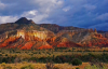
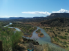
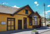
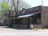
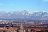
The second-largest city in the state of New Mexico (after Albuquerque), Las Cruces is located at the southernmost part of the state, on the border with Mexico. The area surrounding the city was populated for centuries by the indigenous Manso and Mescalero Apache peoples, and in 1598 was colonized by the Spanish. The territory became part of Mexico in 1821, when Mexico declared independence from Spanish rule, and was simultaneously claimed by the Republic of Texas. In 1848, at the end of the Mexican-American War, the territory was declared to be part of the U.S. and the small settlement of Las Cruces was established as a center for local agriculture. The city grew significantly with the arrival of the railroad in 1881, the founding of New Mexico State University in 1888, and with the development of the White Sands Missile Range and Test Facility in the 1940s.

The name "Las Cruces" means "the crosses" in Spanish. Although the origin of the name is unknown, it is commonly believed that the city was named after crosses marking graves of explorers and soldiers that were found in the area.

Pages

Subscribe to RSS - Geographic Reference