Geographic Reference

Ganado High School, Arizona

Ganado High School is located on the Navajo Reservation in Northeastern Arizona. Most of the students who attend Ganado High School are Native American. The school is a member of the Arizona Interscholastic Association and its mission is “to ensure all students a quality education and strengthen Diné cultural values for life-long learning.”

Corn Mountain, New Mexico

Also known as Dowa Yalanne in the Zuni language, Corn Mountain is the mesa located southeast of the current Zuni pueblo in central New Mexico. The mesa has historical as well as spiritual significance for the Zuni. In the early sixteenth century, the Zuni took refuge from Spanish conquistadors atop the mesa. Later, during the period of the Pueblo Revolt at the end of the seventeenth century, the Zuni again retreated to the mesa top. In addition, the mesa is the site of several living shrines and cultural routes, and it retains astrological significance from which the Zuni ceremonial calendar is derived.

Ceniza Mesa, Arizona

Ceniza Mesa is also known as Toh Chin Lini, which means “Water Flowing Out” in Navajo. Ceniza Mesa is located on a western ridge of the Carrizo Mountains in northeastern Arizona.

Central Park, New York City, New York

Central Park is a large, sprawling, architecturally landscaped urban park located in the center of Manhattan in New York City, New York. The idea for the park began in the 1840’s as New York City became more and more urbanized. Two men, William Cullen Bryant and Andrew Jackson Downing, called for a park to be built to give the people of the city a green place. The New York state legislature set aside around five million dollars to create the park. Central Park was designed by Frederick Law Olmsted and Calvert Vaux and encompasses 840 acres. The park opened in 1876 and now is the most visited urban park in the world.

Carrizo Mountains, Arizona

This an isolated mountain range of extinct volcanoes located in northeastern Arizona within the Navajo Reservation. These mountains are part of the Chuska-Tunicha-Lukachukai-Carrizo mountain chain, the highest peak of which is Pastora Peak. In Spanish, “Carrizo” means “Reed Grass,” whereas the Navajo word for this mountain range is Dził Náhooziłii, which means “Mountain that Gropes Around.” These mountains constitute the lower extremities of the Navajo mythological being Yódí Dziil (Wealth Mountain), whose enormous prone body is comprised of the linked chains of mountains listed above.

canyon country

A general reference to much of the Four Corners region of the U.S., whose geological distinctiveness is in great part derived from the riddles of canyons, large and small, that break the terrain of this part of the country into a series of interlinked canyon systems, fragmented watersheds, and iconic geologic formations.

Vietnam

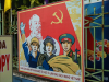
A small country in Southeast Asia that is bordered by China, Laos, and Cambodia, Vietnam has a long, rich history that predates the rise of Western civilization. However, its significance in recent history and as a reference in Tony Hillerman’s novels emerges in the context of what is known as the Vietnam War, one of the most costly and controversial foreign wars fought by the U.S. The background for the Vietnam War involves the aftermaths of French colonization in the country, which lasted from 1859-1954. In 1954, after a series of violent battles, the country gained its independence, but growing tensions between political factions in the region left it divided, with the North advocating full communist affiliation with the Soviet Union and China, and the South perceiving the former French colony as part of the West. Thus, the country was caught in the intricacies of the global Cold War. When violent clashes between the Viet Cong (the Northern army), and the Southern forces escalated in the late 1960s, the American government began deploying troops in increasing numbers in a demonstrative attempt to enforce Western dominance in Vietnam and in Southeast Asia as a whole. However, what at first appeared to be a temporary military operation turned out to be a prolonged and deadly war, and one that the U.S. has bitterly lost.

N.M. 53

A New Mexico state highway that originates in Grants, New Mexico and heads first south and then roughly west through the Ramah Navajo and Zuni reservations, until it turns into Arizona S.R. 61 at the Arizona/New Mexico state line.

Round Rock, Arizona

Round Rock, also known as Tsé Nikani (Flat Plated Rocks) in the western part of the Navajo Reservation and Bis Dootl'izh Deez'ahi (Blue Pointed Mesa) in the eastern part, is located on the Navajo Reservation in Apache County, Arizona and is named after a nearby mesa. In 1892, Roundrock was the site of a clash between the Bureau of Indian Affairs and a Navajo leader called Black Horse. Indian Agent Henry Shipley attempted to forcefully remove Navajo children from their homes in Round Rock and relocate them to Native American boarding schools. Black Horse attempted to prevent the removal and re-education of the children, which he associated with cultural genocide, by barricading Agent Shipley and his men in the Chee Dodge trading post, rather than killing them, until troops from Fort Wingate arrived and were able to defray the situation. The Chee Dodge Trading Post remained in business until early 2013.

Window Rock, Arizona

A small settlement located on the Navajo Nation Reservation in northeastern Arizona, close to the New Mexico-Arizona state line. Window Rock, which was established in the 1930s as the base of the Navajo Central Agency, is the capital of the Navajo Nation. The Navajo Nation Council, the Navajo Nation Supreme Court, the headquarters of the Navajo Police, and various other administrative offices are all located in Window Rock. The town was named Window Rock after the adjacent sandstone arch of the same name, known in the Navajo language as Tségháhoodzání, which means “Perforated Rock.” The unique rock formation is one of the town's famous tourist attractions, along with the Navajo Nation Museum, the Tribal Zoological and Botanical Park, and the Navajo Code Talkers World War II Memorial.

Pages

Subscribe to RSS - Geographic Reference