The Dark Wind (1982)

The Dark Wind (1982)

The Dark Wind, Revised Manuscript (Photocopy).

This is a photocopy of a completed manuscript for The Dark Wind. This manuscript includes all the front matter of a published book and a note to the Harper & Row editors regarding the contents. It appears to have been marked up by both Harper & Row editors and Tony Hillerman himself. There are notes back and forth between author and editors in the margins regarding plot points. Most interesting, is Hillerman's note about writing his own brief description l for the dust cover because he did not want hints to the plot given away.

The Dark Wind, Manuscript.

This appears to be the first completed manuscript for The Dark Wind. There are only very minor editing in two places. This draft includes possible book titles, the author notes, and the dedication.

The Dark Wind, Assorted Draft Pages and Notes.

This appears to be early assorted pages of various chapters from The Dark Wind. The editing has been done in black and blue ink pen, sometimes on the same page, suggesting that this draft was edited by Tony Hillerman and one other person. Additionally, with the assorted draft pages are Hillerman's research on the Navajo, including: Navajo chronology, linguistic history and kinship charts. Interestingly, there is also the contact information for his writer's group and a syllabus from a Navajo Ethnology class taught at UNM.

The Dark Wind, Partial Draft.

This appears to be a portion of the second draft of The Dark Wind. The editing has been done in black ink, suggesting that this draft was edited only by Tony Hillerman. The editing is heavy is still very heavy and plot points and final details are still being worked on.

The Dark Wind, Draft.

This appears to be the first draft of The Dark Wind. The editing has been done in black, blue, and red ink pen, sometimes all on the same page, which suggests that this draft was edited by Tony Hillerman and at least one other person. The editing is heavy in places and some character names have been added in. Finally, this draft has heavy water staining on some pages and some pages are different colors.

Window Rock, Arizona

A small settlement located on the Navajo Nation Reservation in northeastern Arizona, close to the New Mexico-Arizona state line. Window Rock, which was established in the 1930s as the base of the Navajo Central Agency, is the capital of the Navajo Nation. The Navajo Nation Council, the Navajo Nation Supreme Court, the headquarters of the Navajo Police, and various other administrative offices are all located in Window Rock. The town was named Window Rock after the adjacent sandstone arch of the same name, known in the Navajo language as Tségháhoodzání, which means “Perforated Rock.” The unique rock formation is one of the town's famous tourist attractions, along with the Navajo Nation Museum, the Tribal Zoological and Botanical Park, and the Navajo Code Talkers World War II Memorial.

Tuba City, Arizona

Tuba City is located in Coconino County, Arizona on the southern edge of the Kaibito Plateau. This town is one of the largest communities on the Navajo Reservation but it also has a small Hopi population. During the 1870s, Mormons briefly resided in Tuba City. At that time, Mormons named the community after a Hopi headman named Tuvi, who converted to Mormonism. Mormons later sold the town, which they claimed to be their property, to the U.S. Indian Service (in later years known as the Bureau of Indian Affairs). Mormons had been encountering increasing levels of antagonism from the Navajo, the original inhabitants of the area, which may explain why the Mormons sold the town and left the area.

One Navajo word for Tuba City is Tö Naneesdizí, which means “Place of Water Rivulets,” referring to the irrigation ditches used by Mormons during their occupation.

Teec Nos Pos, Arizona

Teec Nos Pos is a small community located six miles southeast of the Four Corners Monument in Apache County, Arizona. Teec Nos Pos has shifted north from its original location, closer to the Junction of U.S. Highway 160 and 64. The community is composed of a trading post, a chapter house, and a school. The Navajo name for this community is T’iis Názbad which means “cottonwoods in a circle.”

Santa Fe, New Mexico

The state capital of New Mexico, Santa Fe (meaning “holy Faith” in Spanish) is the oldest capital in the United States. At an elevation of over 7000 feet, it is also the highest one. The city was founded in 1610 by Don Pedro de Peralta as the capital of the province of New Mexico under colonial Spanish rule. The lands surrounding the town were occupied by indigenous peoples for centuries before the arrival of the Spaniards, and in fact today’s downtown area sits atop at least two Pueblo ruins.

The city remained small and fairly provincial through the transition from Spanish, to Mexican, and then American rule, but in the early 20th century it established itself as a cultural hub that celebrated a mix of indigenous histories, Hispanic traditions, and modern American influences. The community of artists and writers who were attracted to the area, the most famous of which is the painter Georgia O’Keefe, contributed greatly to the city’s growth and development as a tourist destination.

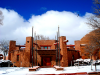
Santa Fe’s economy has come to rely heavily of tourism, promoting a romantic, somewhat exotic image of a small city that boasts numerous attractions such as museums and art galleries, a historic plaza at the heart of downtown, old churches, Pueblo architecture, and high-end boutiques and restaurants. The upscale attractions, along with the area’s natural beauty, have attracted a wealthy population that has gradually displaced many of the city’s original residents. Today Santa Fe stands in stark contrast to the neighboring small towns and even the bigger city of Albuquerque, communities that struggle with stunted economic development and a lack of resources.

Sangre de Cristo Mountains, Colorado & New Mexico

One of the longest mountain ranges in the world. The range begins at Poncha Pass in Colorado and extends 204 miles south to Glorieta Pass near Santa Fe, New Mexico. The Spanish explorer Antonio Valverde y Cosio named the mountain range “Blood of Christ” in Spanish, remarking on its red color at sunrise. Blanca Peak is the highest point of the range, reaching over 14,000 feet. The headstreams of the Pecos and Canadian rivers begin in the mountain range. The range is a part of San Isabel, Rio Grande, Carson, and Santa Fe national forests and includes a number of national monuments. The mountains are popular among tourists and have also been exploited by the mining industry.

Pages

Subscribe to RSS - The Dark Wind (1982)