The Blessing Way (1970)

The Blessing Way (1970)

wagon track

A two-track path created by four-wheeled wagons drawn by draft animals such as oxen or horses. The wheels created two ruts, marking routes that other travelers could follow and that left traces over the landscape that could be read for centuries. Travelers in wagons would often follow routes already created by indigenous peoples, appropriating traditional travel ways that had been previously used for trade and pilgrimage.

Harvard-Smithsonian

A reference to collaborative Southwestern archaeological excavations of the early 20th century completed by Harvard’s Peabody Museum of Archaeology and Ethnology in conjunction with the Smithsonian Institution. These excavations include sites such as Mesa Verde and Pueblo Bonito, among others.

The Peabody Museum of Archaeology is a museum associated with Harvard University in Cambridge, Massachusetts and funded excavations in archaeological sites throughout the U.S. Similarly, the Smithsonian backed many large excavations in the Southwest. The Smithsonian is a private institution that is in the trust of the U.S. government and funds museums, research centers, libraries, and more. The Smithsonian is based in Washington D.C.

Corona, New Mexico

A village near the base of the Oscura Mountains located in Lincoln, New Mexico along U.S. Route 54. The area of Corona was initially settled by Spanish sheep and cattle ranchers. The community was not incorporated as a town until 1903, when a stop for the South Western Railroad was created.

Hall, New Mexico

A fictitious town near the Oscura Mountains in Socorro County in central New Mexico. A small community mentioned in Tony Hillerman's 1970 Navajo detective novel THE BLESSING WAY, Hall is a town close to the home of the novel's antagonist Jim W. Hall. The Oscura Mountains happen to be at the north end of White Sands Missile Range and are also the site of an Air Force Research Laboratory, an interesting tie-in to the novel's plot.

Toh-Chin-Lini Butte, Arizona

A butte, or stand-alone mesa, located in Apache County in northeastern Arizona, which shares the same name with a nearby canyon. In Navajo, toh-chin-lini means “water flowing out.” Located near Black Rock Point and along the west slope of the Carrizo Mountains, this mesa is also known as Ceniza Mesa.

Seklagaidesi, Arizona

Also known as Seklagidsa or Tselagideza Canyon, located in the western slopes of the Carrizo Mountains in Apache County, Arizona. There is also a canyon by the same name nearby. In Navajo, Tselagideza means “Prominent White Cliffs." The head of Walker Creek begins in this canyon and further down it joins with Alcove Canyon.

Cortez, Colorado

A city in southern Colorado located along the Dolores River. This city was named after the Spanish conquistador Hernán Cortés, who conquered the Aztecs in Mexico. Many places in this area, including Montezuma Valley, Montezuma County, and Cortez itself, are named after people associated with the Aztecs, because the region was originally thought to have been inhabited by the Aztecs rather than the Ancestral Puebloans.

This city is the seat of Montezuma County. The modern city was founded in 1886 by the Montezuma Valley Company, who built a canal running from the Dolores River into the town to provide water for irrigation and livestock. Prior to modern settlement this area was inhabited by the Ancestral Puebloans, Ute, Arapaho, and the Navajo.

Agua Sal Wash, Arizona

A wash within a valley located in Apache County, Arizona. This wash flows northwest into the larger Lukachukai Wash and was named “Salt Water Wash” in Spanish by 20th-century hydrologist Herbert Gregory from the United States Geological Survey. The Navajo name for Agua Sal Wash is Tó Dík’ ǫ́ǫ́zh (Saline Water).

Ceniza Ridge, Arizona

A ridge, also referred to as Ceniza Saddle, that forms part of the geologic formation known as Ceniza Mesa, also referred as To Chin Lini, meaning “Water Flowing Out,” in Navajo. This ridge is part of the western slopes of the Carrizo Mountains in northeastern Arizona.

A ridge is a continuous elevation of land that extends in a line between higher mountain peaks. Sometimes ridges descend from a higher peak toward lower elevations, giving a mountain a vertically-grooved appearance. Occasionally, ridges occur as singular components of the landscapes. A saddle ridge is a geographic term that refers to the outline of a mountain in which a gentle concave depression lies between two peaks. As the name suggests, the shape would then resemble a saddle used for horse riding, where the seat slopes down into a low curve between the slightly higher parts of the front and the back.

Carolinas

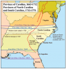
A reference to two separate states, North Carolina and South Carolina. The Carolinas are located on the east coast of the United States just below Virginia. During the U.S.'s colonial period, both were part of the large Province of Carolina, which encompassed much of the southeastern U.S. However, in 1729, the Province divided into two entities, each informed by a distinct form of agriculture, one belonging to the original British settlers of the Colony of Virginia, of which the Province of Carolina was part, and one influenced by the British slavery plantations in the Caribbean.

The Carolinas were both involved in the American Revolutionary war as Anglo settlers struggled to assert their economic and political autonomy from Britain. South Carolina became a state in in 1788 and North Carolina a year later in 1789. Later, during the American Civil War, both Carolinas seceded from the Union to fight on the side of the Confederacy. The legacy of slavery-based economies and nostalgia for old-world traditions associated with the Confederacy find expression today especially in South Carolina with its ongoing debate regarding flying the Confederate flag on its state buildings.

Pages

Subscribe to RSS - The Blessing Way (1970)