Geographic Reference

Railroad Avenue, Gallup, New Mexico

The former name of what is now Historic Route 66, the main street in Gallup, which runs parallel to the railroad and crosses the town from east to west.

Pasadena Airport, California

Originally called the United Airport, this airport has undergone five name changes since it was built in 1930. This airport is located in Burbank, California and was known as the Burbank-Glendale-Pasadena Airport from 1978 - 2003. The airport is currently called the Bob Hope Airport, after the famous comedian, and services more than 10,000 commercial flights a year.

Phoenix, Arizona

The capital city of the state of Arizona, Phoenix is also known as the “Valley of the Sun.” It was originally settled as an agricultural area that modeled its early irrigation systems on the ancient Hohokam canal system that riddled the valley floor. As with most Southwestern frontier towns Phoenix went through several iterations including periods of Mexican and New Mexican territorial management. The entrance of the railroad, and later the post-World War Two automobile and baby booms, led the city’s population to soar. Phoenix became one of the largest cities in the U.S., despite being located in one of the most water-poor fringes of the Sonoran desert.

Philadelphia, Pennsylvania

The largest city in Pennsylvania, founded by William Penn in 1682 during the U.S. Colonial period. Philadelphia is popularly known as the “city of brotherly love” from the Greek translation of the name. It is located in eastern Pennsylvania between two rivers, the Delaware and the Schuylkill. The U.S. Declaration of Independence (1776) and Constitution (1787) were signed in Philadelphia.

Page, Arizona

Originally, Page was a temporary housing site for the Glen Canyon Dam construction workers and their families and was called the Page Government Camp after the Bureau of Reclamation commissioner John C. Page. The housing camp was created in 1957 and included thousands of temporary homes constructed for the workers along the Colorado River. The land that the town stands on was originally a part of the Navajo Nation, but a deal was struck whereby a tract of land in Utah was exchanged for the area in and around Page.

It took seven years for Glen Canyon Dam to be completed, and during this time permanent homes, churches, and infrastructure were constructed in Page. By 1964 the town was a federal municipality, and in 1975 it became an incorporated town. When the dam was finished, water was captured on the north side of the dam, creating Lake Powell Reservoir. The reservoir is named for John Wesley Powell, a Civil War veteran and explorer. Today, Page sits on the south shore of the Lake Powell and is a popular vacation spot.

Owl Springs, New Mexico

A spring located along Indian Service Route 32 in the Navajo Nation Reservation and near Shiprock and Narbona Pass in San Juan County, New Mexico. Springs are areas on the landscape where groundwater is pushed to the surface, either by gravity or pressure, through unconsolidated sediment or fractures in the bedrock. They often manifest as ponds or seeps of water on the surface.

Oscura Mountains, New Mexico

The Oscura Mountains are a landform located in the northern portion of White Sands Missile Base in Lincoln County, New Mexico, just north of the San Andres Mountains and east of Tularosa Valley. In Spanish, Oscura means “dark,” and this name references the dark volcanic formations and vegetation on the mountains. Within the range is North Oscura Peak, the location of the Air Force Research laboratory, which is associated with White Sands Missile Range.

Oscura Foothills, New Mexico

The Oscura Foothills are the low-rise hills located along the base of the Oscura Mountains, a range in Lincoln County, New Mexico.

Mount Taylor, New Mexico

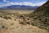
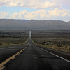
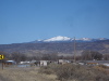
At 11,306 feet, Mount Taylor is the highest peak in the San Mateo range, located about 15 miles northeast of Grants, New Mexico. In the winter its snow-capped peak is especially noticeable. During the Spanish rule of the region, the mountain was called Cebolleta (little onion). In 1849, after the U.S.-Mexico War, it was renamed after President Zachary Taylor. For the indigenous peoples of the area, Mount Taylor is a revered and spiritually significant location. In Navajo it is known as Tsoodzil (Turquoise Mountain) and is one of the four sacred mountains that mark the Navajo homeland.

According to Hillerman's version of Navajo mythology, First Man buried turquoise in this range, hence its symbolic blue color. Under Hillerman's interpretation, the chief of the Enemy Gods, Yé'iitsoh, once resided in this peak. When the Twin War Gods (Born for Water and Monster Slayer, sons of Changing Woman) killed Yé'iitsoh, his blood spilled down the slopes and hardened into the lava flows of El Malpais in the area surrounding Grants. The mountain features as a central and meaningful location for Blessingway and Enemyway ceremonies.

Oklahoma City, Oklahoma

The capital, and largest city, in the state of Oklahoma. The city was founded in 1889, after homesteaders in the area staked claims to farmlands that were originally Native American territories along the North Canadian River in what is now central Oklahoma. The town developed as an agricultural and livestock trading center but over time its economy grew and diversified to include the petroleum, aircraft, automobile, and electronics industries. In 1995, the city made international news when a deadly attack of domestic terrorism killed 168 people at the Alfred P. Murrah Federal Building.

Pages

Subscribe to RSS - Geographic Reference