
Article
Thoreau, pronounced "through" in English, is a small community located just north of Interstate 40, about 30 miles east of Gallup, New Mexico. The Navajo name for the village is Dlǫ́ʼí Yázhí meaning "Little Prairie Dogs." The town grew around a sawmill that was built there in 1881, with the arrival of the Atlantic and Pacific Railroads. After the closing of the sawmill in 1890, the village was a trading center for Navajo rugs, crafts, and jewelry. When Highway 66 (now Interstate 40) was rerouted in 1937 it no longer passed through the town and trading declined significantly. Mining, especially of uranium, became the main source of the town’s livelihood until the 1980s, when mining companies in the area ceased their operations. A number of schools are located in the town including the Thoreau Elementary, Middle, and High schools; a Bureau of Indian Affairs boarding school; and the Saint Bonaventure Catholic School.
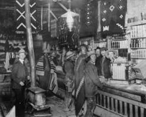
"Group inside trading post, Thoreau, New Mexico, circa 1900," photograph, (009123). Palace of the Governors Photo Archive, New Mexico History Museum, Santa Fe, New Mexico. Use with permission only.
Manuscripts
References
Adair, John
1944 The Navajo and Pueblo Silversmiths. Norman: University of Oklahoma Press.
Heath, Roxanne Trout
1982 Thoreau, Where the Trails Cross! Thoreau: R.T. Heath.
Linford, Laurance D.
2001 Tony Hillerman's Navajoland: Hideouts, Haunts, and Havens in the Joe Leaphorn
and Jim Chee Mysteries. Salt Lake City: University of Utah Press.
Tsosie, Nathania
2012 Native Artists Helping Our People Endure (HOPE): A Social Capital Analysis of a
Grassroots Art Initiative to Address Youth Suicide in an Indigenous Community. MA
thesis, University of New Mexico, http://hdl.handle.net/1928/17457, accessed July 9,
2015.