Article
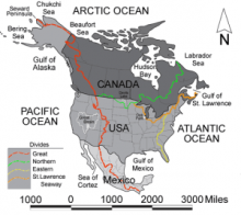
Generally speaking, a continental divide is a geographic formation usually located on a continent’s high mountain peaks. Continental divides separate water drainage in two different directions, either vertically or horizontally. On one side, water flows either north or south; on the other side, water flows east or west. Water travels to the nearest ocean or sea often via long rivers. In North America, the continental divide (also known as the Great Divide) is a chain summits of the Rocky Mountains that are aligned in a fairly continuous contour from north to south along the western parts of the continent. The ranges traverse British Columbia in Canada; and Montana, Wyoming, Colorado, and New Mexico in the U.S. The Rocky Mountains separate drainage so that on the eastern side water will flow mostly to the Mississippi and the Rio Grande Rivers, eventually reaching the Gulf of Mexico and the Atlantic Ocean, while on the west side water will move in the direction of the Pacific Ocean.
"Map of the North America Continental Divides" by Don Braffitt is licensed under Public Domain.
Manuscripts
References
Encyclopedia Britannica Online
N.d. Continental Divide.
http://www.britannica.com/EBchecked/topic/134892/Continental-Divide, accessed June
1, 2015.

