The Blessing Way (1970)

The Blessing Way (1970)

Maryland

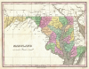
A small state located in the east-central coast of the United States of America, named after the wife of the British King Charles I. This state was one of the original 13 colonies and was incorporated in 1632. After the American Revolution, Maryland became a state on April 28, 1788.

During the American Civil War Maryland remained a neutral border state between the Union and the Confederacy, as its population was split between those who supported the North and those who supported the South. It was the location for an important battle during this war, the Battle of Antietam, which ended in a stalemate. After the Battle of Antietam, President Abraham Lincoln issued the Emancipation Proclamation, which declared the manumission, or freedom, of African American slaves in the U.S., even though the decree was not legally binding until the 13th Amendment to the U.S. Constitution was passed in 1865.

Many Farms, Arizona

Also known as Da’ah’eh Halani in Navajo, Many Farms is a small, primarily Navajo community about 15 miles north of Chinle, with a trading post, chapter house, and historic agricultural foundation. Although the community pre-existed the confluence of US Highway 191 and Navajo Route 59, it was only after 1937 and the damming of Sheep Dip Creek to create Many Farms Lake that the community began to develop in terms of emerging infrastructure.

Los Gigantes Buttes, Arizona

This geologic feature consists of large, craggy, sandstone buttes located almost midway between Chinle and Lukachukai on the Navajo Reservation in Apache County in northeast Arizona. The Navajos call this place Tsé Ch’deelzhah, which means “rocks jut out.”

Lukachukai Mountains, Arizona

The Lukachukai Mountains are a mountain range in northeastern Arizona that lay entirely within the Navajo Reservation. The highest point of the range is an unnamed point at 9,466 feet above sea level. The mountains are still largely used as summer ranges for sheepherding. For that reason, the range is called Shíík'eh (A Summer Place) in Navajo. In Navajo mythology, this mountain range, along with the Carrizo Mountains, forms a prone male figure called Yódí Dziil (Wealth Mountain). Ch'óshgai (Chuska Mountains) forms the head; Leezhch'iih Deezgai (western Lukachukai Mountains) forms the chest, abdominal areas, and limbs; and Dzi Náhoodziii (Carrizo Mountains) forms the feet.

mesquite

Mesquite is a spiny, desert legume which grows in two forms: a low-to-the-ground prickly shrub and a tree that grows up to fifty feet tall. Mesquite grows in thickets throughout the Southwest, and due to the dryness of this environment, the roots grow deep in order to reach water. Mesquite wood can be used for furniture and for sweet-smelling firewood. The beans that grow from the plant are sweet and, when roasted and ground into a flour, have comprised a significant food source for many indigenous desert dwelling populations in the region.

Mesa Verde National Park, Colorado

A national park located in southwestern Colorado covering a broad cultural landscape that includes numerous prehistoric cliff dwellings.In 1906, President Theodore Roosevelt designated Mesa Verde National Park to protect what was considered one of the largest and best-preserved archaeological sites in the world. In 1978, Mesa Verde was also designated as a protected UNESCO World Heritage site.

The prehistory of Mesa Verde reaches back to around 550 CE, when Basketmaker people built subterranean pit houses on the top of Mesa Verde’s large sandstone plateaus and grew corn. By 750 CE, the occupants of this region began to build pueblos with room blocks and ceremonial kivas above ground. Finally, around 1150-1200 CE, the Ancestral Puebloans began constructing large multi-story dwellings within deep alcoves on the sides of the mesas, which had been created by water erosion. The alcoves chosen for occupation were generally on the south-facing side of the mesas in order to take advantage of as much seasonal passive solar heating and cooling as possible. The most famous of these cliff dwellings is Cliff Palace, a 200-room, multi-story pueblo ruin located in the Great Mesa. These dwellings were occupied until 1300 CE when a drought drove the people out of the region.

mesa

A flat-topped hill or plateau of rock with one or more steep sides, usually rising abruptly from a surrounding plain. Commonly found in arid environments, mesas are formed by the erosion of horizontally layered rocks that have been pushed above the surface of the earth by tectonic activity.

juvenile record

A written account of any criminal wrongdoings committed by a person under the age of 18. These records are private and not available to the general public. Moreover, these records can be sealed at the request of the petitioner, who may be either the subject of the records or someone speaking on his or her behalf. Before 1889, children were tried as adults in court and subject to the same punishments given to adults. With the advent of the Juvenile County System, juveniles are now tried in a special court and sent to Juvenile Detention, not adult prison.

fingerprints

An imprint made by the ridges, crests, and arches that adorn the soft pads aon our fingertips. These imprints are created by ridges that are present on the epidermis (the outer layer of the skin) on the palm side at the tips of every person's fingers. When a person touches something, the naturally-occurring oils produced by the skin leave traces in the shape of the ridges of their skin. These imprints are unique to each person, which allows fingerprints to be used as identification during criminal investigations. Some consistent fingerprint patterns have been identified, including double loops, central pocket loops, loops, plain whorls, plain arches, and tented arches.

warhead

The portion of a missile, torpedo, or similar weapon that contains the material, explosive, biological, or nuclear, that hits the target first, detonating upon impact.

Pages

Subscribe to RSS - The Blessing Way (1970)