The Dark Wind (1982)

The Dark Wind (1982)

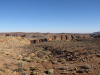
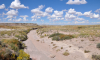
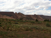
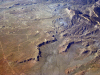
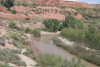
Nipple Butte, Arizona

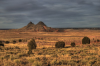
One of a chain of volcanic mesas and buttes that lies between Interstate 40 and the Hopi mesas on the Navajo Indian Reservation in northeastern Arizona. The area is characterized by its rough and barren terrain and for its striking geologic formations. It is important to both Navajo and Hopi peoples, and features in various migration stories.

Cedar Ridge Trading Post, Arizona

Established in 1920 by white settlers in Northern Arizona, this trading post is named after a nearby geologic feature by the same name. It is located on Highway 89, on the western side of the Navajo Indian Reservation. A trading post is an establishment where goods can be traded. It is also a social center where news and gossip are exchanged. Trading posts have been associated with American frontier culture since the seventeenth century. Over time, trading posts developed into a cultural institution at first funded and backed by empire, later by national interests, and most often by enterprising business men.

Yon Dot Mountains, Arizona

Although called mountains, these are in fact a chain of low hills located in the western part of the Navajo Indian Reservation in northern Arizona. The origin of the name Yon Dot is unclear. In Navajo these hills are called Yaa Ndee’nil, which simply means “series of hills going down.”

Twentynine Mile Wash, Arizona

A canyon and dry stream located at the juncture of the Colorado River and the Little Colorado River on the Navajo Indian Reservation in northern Arizona, close to the eastern edge of the Grand Canyon. The deep wash stretches across 29 miles, hence its name.

Balakai Arroyo, Arizona

A dry stream that cuts through the Balakai Mesa, a part of the Black Mesa area on the Navajo Indian Reservation in northeastern Arizona.

Balakai Point, Arizona

Part of the Black Mesa mountainous area on the Navajo Indian Reservation in northeastern Arizona. Balakai Point forms the tip of Balakai mesa, which is associated with the Navajo Blessingway ceremony.

Cottonwood, Arizona

A small town located on the Navajo Indian Reservation in northeastern Arizona. The community, which was established around a trading post, still functions as a modest commercial center, and has a school, a library, and a community center.

Dzilidushzhinih Peaks, Arizona

Part of the large Black Mesa mountainous area of the Navajo Indian Reservation in northeastern Arizona, the Dzilidushzhinih Peaks appear to be the same as Little Black Spot Mountain, located about five miles southwest of the small village of Piñon, Arizona. In Navajo, "Dzil Dah Zhin" means Black Speck Mountain.

Moenkopi Wash, Arizona

A tributary of the Little Colorado River, the Moenkopi Wash is a 90-mile long stream that runs through the Moenkopi Plateau in northern Arizona, along the border between the Navajo and the Hopi reservations. The flat lands along the stream have been traditionally used by both Navajo and Hopi peoples to cultivate crops. The area surrounding the wash's path is known for its colorful canyons and unique sandstone rock formations.

U.S. Highway 160

Part of the United States road system, Highway 160 is an east-west route that crosses the states of Missouri, Kansas, Colorado, New Mexico, and Arizona. Its eastern terminus is in Poplar Bluff, Missouri, and its western terminus is just outside Tuba City, Arizona.

Pages

Subscribe to RSS - The Dark Wind (1982)