Article
The Checkerboard area of the Navajo Nation extends over the eastern part of the reservation, across McKinley, San Juan, and Cibola counties in New Mexico. Beginning with the Dawes Act of 1887, Native Americans, including the Navajo, were assigned plots of reservation land on which to practice subsistence farming. This was an attempt to assimilate Native Americans into Western European land use and domestication practices. Later, pieces of land were granted to the Santa Fe Railroad in the late 1800s, and other tracts were sold to individual non-Native owners. Checkerboarding expanded when Native reservations expanded into lands that were previously sold to or appropriated by non-Native parties.
The checkerboard mix of lands owned by tribes, trust lands, fee lands, and privately-owned tracts severely impedes on the Navajo nation's ability to farm, ranch, or utilize the land for other economic purposes. Problems of mixed jurisdiction (tribal, federal, state, or county) have also contributed to economic instability, as well as to racial tensions and community conflicts. For many years, changing legal jurisdictions meant that law enforcement was extremely difficult on the Checkerboard Reservation. In the early 1980s, however, the Navajo Nation entered a Joint Power Agreement with the State of New Mexico, giving each entity authority to enforce law within the other's jurisdiction. The agreement has enabled much more effective law enforcement procedures.
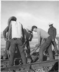
"Navajo men laying railraod track, New Mexico, circa 1950," photograph, (183124). Palace of the Governors Photo Archive, New Mexico History Museum, Santa Fe, NM.
Manuscripts
A06 People of Darkness (03-06) p. 27
A06 People of Darkness (03-06) p. 45
A06 People of Darkness (03-06) p. 46
A06 People of Darkness (03-06) p. 47
A06 People of Darkness (03-06) p. 94
A06 People of Darkness (03-06) p. 111
A06 People of Darkness (03-06) p. 124
A06 People of Darkness (03-06) p. 148
A06 People of Darkness (03-06) p. 183
A06 People of Darkness (03-06) p. 194
A06 People of Darkness (03-06) p. 198
A06 People of Darkness (03-06) p. 233
References
Indian Land Tenure Foundation
N.d. Checkerboarding. https://www.iltf.org/land-issues/checkerboarding, accessed
October 6, 2014.
Linford, Laurance D.
2001 Tony Hillerman's Navajoland: Hideouts, Haunts, and Havens in the Joe Leaphorn
and Jim Chee Mysteries. Salt Lake City: University of Utah Press.