Article
A main street that runs east-west through some of Albuquerque's oldest neighborhoods including Old Town, Downtown, the University District, and Nob Hill. Central Avenue functioned for many decades as the city's major thoroughfare, as well as its commercial and cultural heart, although in recent years it has declined with the construction of the I-40 freeway.
Central Avenue was built along a prehistoric route used by the area's indigenous communities to connect the Rio Grande in the west to Tijeras Canyon in the east for trade and spiritual purposes. With the arrival of the Spaniards in the late 1600s, the route was used to connect the Camino Real (the north-south axis along which Spain developed its colonies) with small Spanish villages in the eastern foothills, and when New Mexico became a U.S. territory in 1848, the east-west expansion brought about the development of a road that would connect the East Coast with the new western states. In 1937, with the redirection of Route 66, Central Avenue became part of this historic cross-country highway, bringing travelers and an emerging tourist industry to Albuquerque. In the 1960s, with the opening of Interstate 40, which replaced Route 66, Central Avenue began to see a significant and steady decline. These days, although some historical preservation and revival attempts are ongoing in the city, and the Downtown area as well as Nob Hill do boast new businesses and a thriving night life, many sections of Central Avenue reveal the effects of economic recessions.
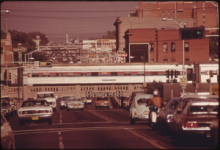
"Amtrak's Southwest Limited Crossing Central Avenue in Downtown Albuquerque, New Mexico, June 1974" by Charles O'Rear, U.S. National Archives and Records Administration is licensed under Public Domain.
Manuscripts
References
Childs, Mark C.
1996 The incarnations of Central Avenue. Journal Of Urban Design 1, no. 3: 281.

