Article
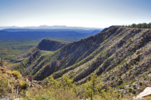
A vast rugged escarpment that stretches over about 200 miles along the southern edge of the Colorado Plateau in east-central Arizona. The Mogollon Rim was named after Juan Ignacio Flores Mogollon, who was the Spanish governor of what is now New Mexico during the years 1712-1715. This southernmost part of the Colorado Plateau forms a definitive separating line between the low-elevation deserts flats surrounding it and the high country of mountains and pine trees above it. The highest points on the rim reach up to 2,000 feet, offering impressive views of the landscapes below.
"Mogollon Rim, Arizona, USA, October 15, 2009" by Brady Smith is licensed under CC BY-SA.
Manuscripts
References
Payson Rim Country
N.d. The Mogollon Rim.
http://paysonrimcountry.com/Mountain-Recreation/NaturalLandmarks/Mogoll…,
accessed September 29, 2015.
USDA Forest Service: Coconino National Forest
N.d. Mogollon Rim Ranger District.
http://www.fs.usda.gov/recarea/coconino/recarea/?recid=54886, accessed September 29,
2015.

