Geographic Reference

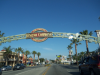
Central Avenue, Albuquerque, New Mexico

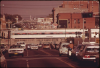
A main street that runs east-west through some of Albuquerque's oldest neighborhoods including Old Town, Downtown, the University District, and Nob Hill. Central Avenue functioned for many decades as the city's major thoroughfare, as well as its commercial and cultural heart, although in recent years it has declined with the construction of the I-40 freeway.

Central Avenue was built along a prehistoric route used by the area's indigenous communities to connect the Rio Grande in the west to Tijeras Canyon in the east for trade and spiritual purposes. With the arrival of the Spaniards in the late 1600s, the route was used to connect the Camino Real (the north-south axis along which Spain developed its colonies) with small Spanish villages in the eastern foothills, and when New Mexico became a U.S. territory in 1848, the east-west expansion brought about the development of a road that would connect the East Coast with the new western states. In 1937, with the redirection of Route 66, Central Avenue became part of this historic cross-country highway, bringing travelers and an emerging tourist industry to Albuquerque. In the 1960s, with the opening of Interstate 40, which replaced Route 66, Central Avenue began to see a significant and steady decline. These days, although some historical preservation and revival attempts are ongoing in the city, and the Downtown area as well as Nob Hill do boast new businesses and a thriving night life, many sections of Central Avenue reveal the effects of economic recessions.

Las Vegas, Nevada

Located in southeastern Nevada, the city of Las Vegas is a major American tourist destination famous for its flashy casinos, themed hotels, shopping, and large entertainment venues. Nomadic Anasazi and Paiute Native peoples roamed the area until the arrival of Spaniards in the early 1800s. In 1909, the American town was founded as a small railroad service station built on marshland surrounded with grassy meadows, which are the source of its name (in Spanish: "the meadows"). The water that was once abundant in the valley has now mostly dried up due to extensive pumping, the city is known for its hot desert climate and long spells of drought. Las Vegas grew significantly in the 1930s with the construction of the nearby Hoover Dam but it wasn't until after World War II that major entrepreneurs started investing in the city's developing gambling industry. "The Strip" is a long central stretch of Las Vegas Boulevard that underwent rapid growth in the 1960s and over the past few decades has become the main attraction of the city. The Strip boasts immense, architecturally extravagant hotels and casinos that form a postmodern pastiche of old and new styles, imitations of world-famous sites (such as Venice, Paris, New York, or the Egyptian pyramids), and gaudy restaurants and shopping centers.

San Jose, California

The third largest city in California (after Los Angeles and San Diego), San Jose is located about 50 miles southeast of San Francisco. Its inland location and semi-arid climate make for mild, sunny weather year-round. The area of the Santa Clara valley, in which San Jose is located, along the Guadalupe River, was inhabited by the Costanoan Native peoples until the arrival of European settlers in the mid-1800s. In 1877, Spanish farmers established the first permanent settlement in California at the site of what is today the city of San Jose, and named it Pueblo de San Jose de Guadalupe. When the Americans took over the state in 1846, the town functioned briefly as California's capital, which was moved to Vallejo in 1852, and then permanently to Sacramento in 1854. Farming and agriculture continued to be the basis of San Jose's slowly-growing economy until World War II when aircraft, motor vehicle, and electrical machinery firms built large plants in the city, generating a rapid growth in both population and land area. In the 1990s, with the rise of the high-tech computer industry, the city became known as the hub of Silicon Valley, which resulted in increasing population diversity, rising cost of living, and many of its neighborhoods turning into affluent suburbs.

Nevada

The 36th state to join the union, Nevada sent their entire constitution to the U.S. capitol via telegram to speed up the admission process. The state is the seventh largest in the U.S. and one of the least populated. Although most of the state is desert, Nevada sits between the Rocky Mountains and the Sierra Nevadas, and is home to the largest number of mountain ranges in any state. Because of the difficult terrain, the area was one of the last in the western part of the U.S. to be explored. A gold rush in the mid-nineteenth century, however, brought many new explorers to the area.

The capital, Carson City, is smaller and less famous than Las Vegas, which is a popular tourist destination known for its casinos and entertainment venues. Gambling and prostitution are both legal in Nevada, and the state hosts the annual Burning Man event. The state is home to Hoover Dam, the largest public works project in U.S. history; Lake Mead, the resulting reservoir that is also the nation's largest; as well as Area 51, the CIA's secret development and military testing headquarters.

Encino, California

A wealthy Los Angeles suburb, located in the San Fernando Valley, in the northwestern part of the city. Encino was home to the Grabielino Native peoples and was colonized by the Spanish in 1769 and given its name, which is Spanish for “oak tree.” During the 1840s, Vincent De La Ossa acquired ownership of much of the land in the area, establishing a large adobe ranch. Encino is now a major center of business and high-end shopping; many celebrities from the entertainment industry live in the area.

San Francisco, California

San Francisco is the main commercial and cultural center of Northern California. The city was founded in 1776 by Spanish colonizers and grew fairly slowly until the Gold Rush of 1849, which brought about rapid population and economic growth. In 1906, a major earthquake followed by severe fires destroyed nearly three-quarters of the city. The damage was quickly repaired and in the first half of the 20th century the city attracted immigrants from around the world, as well as World War One veterans. In the 1960s and 1970s the hippie, peace, and gay rights movements were centered in the city and to this day it is a highly diverse and liberal hub of alternative culture and progressive social activism. It is a major tourist destination known for its scenic views, restaurants, eclectic architecture, rich history, cultural institutions, and mild weather. Many major technology and start-up companies are located in San Francisco and issues of gentrification and housing insecurity are hotly debated.

Bakersfield, California

A city located in south-central California, about 110 miles north of Los Angeles. It was founded as an agricultural trade center in 1869, and was named after Thomas Baker, who owned much of the land in the surrounding area. The city grew steadily, and its agricultural economy expanded to include diversified industries such as petroleum-based products, steel products, textiles, and electronics.

Anaheim, California

Part of the greater Los Angeles metropolitan area. Anaheim was founded in 1857 by a group of German immigrants who named it Anaheim, which translates from German as "home on the (Santa) Ana River." It is located 25 miles (40 km) southeast of Los Angeles, and is home to Disneyland, one of the most popular tourist destinations in the world.

Los Angeles, California

A large culturally and racially diverse city located in southern California. Los Angeles is the second most populated city in the U.S., after New York City. The name Los Angeles means “the angels” in Spanish and is hence known as the “City of Angels.” Prior to the 20th century, Los Angeles was not the center of movie-making, leisure, or cultural capitalism that we think of today. The city began as a small village that, in order to distribute the water supply from the Los Angeles and Owens Rivers, consolidated a number of neighboring communities to create one large city. It is for this reason that there are a number of distinct city districts within Los Angeles including: Hollywood, San Pedro, Chinatown, Watts, Boyle Heights, Encino, and Little Tokyo. Before the mid-20th century, agriculture thrived within the city as there were many farms, orchards, and greenhouses. When the film industry moved from the East Coast to California, largely due to the availability of natural light and cheap property values, Los Angeles became a cultural and economic hub of the West Coast. Theater, music, and visual art have proliferated since the 1960s, creating an urban renaissance that corresponded with the physical growth of the city. Its warm climate, beaches, and mountains also make it a popular world-wide tourist destination. The city is also known for its major freeways, traffic, and car culture.

This sprawling city is home to many ethnicities, career options, and socioeconomic classes. There are also a number of Navajo peoples living in Los Angeles as a direct effect of the Indian Relocation Act of 1956. This act encouraged Native Americans to leave their reservations and settle down in large cities by offering vocational training, moving expenses, and some economic help when they first arrived in the cities. The act relocated approximately 750,000 Native Americans into major cities, such as L.A., where they often faced cultural isolation, poverty, discrimination, and other adverse effects.

El Paso, Texas

A city located in the far southwestern corner of Texas, on the banks of the Rio Grande, and just across the border from the city of Juárez, Mexico. In Spanish, the name El Paso means "the passage," and indicates the strategic location of the town in Spanish colonial times along the Camino Real Por Tierra Adentro, Spain's "royal road" that traveled north from Mexico City to the Spanish colony's northern frontier. Although a mission was built in the area in 1659 and small settlements were scattered around it throughout the 1700s, it wasn't until 1827 that a permanent village was established in what today is the city of El Paso. The town grew slowly until the arrival of the railway in 1881, after which El Paso saw a significant population increase and a growth in trade, commerce, ranching, agriculture, and mining production.

Today El Paso is an important crossroad for foreign trade, transnational labor, and pan-American transportation. Its history as a Spanish colonial town and its proximity to Mexico make it a bilingual city with strong cross-border influences on its economy, demographics, and culture.

Pages

Subscribe to RSS - Geographic Reference