Geographic Reference

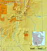
Checkerboard Reservation, New Mexico

The Checkerboard area of the Navajo Nation extends over the eastern part of the reservation, across McKinley, San Juan, and Cibola counties in New Mexico. Beginning with the Dawes Act of 1887, Native Americans, including the Navajo, were assigned plots of reservation land on which to practice subsistence farming. This was an attempt to assimilate Native Americans into Western European land use and domestication practices. Later, pieces of land were granted to the Santa Fe Railroad in the late 1800s, and other tracts were sold to individual non-Native owners. Checkerboarding expanded when Native reservations expanded into lands that were previously sold to or appropriated by non-Native parties.

The checkerboard mix of lands owned by tribes, trust lands, fee lands, and privately-owned tracts severely impedes on the Navajo nation's ability to farm, ranch, or utilize the land for other economic purposes. Problems of mixed jurisdiction (tribal, federal, state, or county) have also contributed to economic instability, as well as to racial tensions and community conflicts. For many years, changing legal jurisdictions meant that law enforcement was extremely difficult on the Checkerboard Reservation. In the early 1980s, however, the Navajo Nation entered a Joint Power Agreement with the State of New Mexico, giving each entity authority to enforce law within the other's jurisdiction. The agreement has enabled much more effective law enforcement procedures.

Thoreau, New Mexico

Thoreau, pronounced "through" in English, is a small community located just north of Interstate 40, about 30 miles east of Gallup, New Mexico. The Navajo name for the village is Dlǫ́ʼí Yázhí meaning "Little Prairie Dogs." The town grew around a sawmill that was built there in 1881, with the arrival of the Atlantic and Pacific Railroads. After the closing of the sawmill in 1890, the village was a trading center for Navajo rugs, crafts, and jewelry. When Highway 66 (now Interstate 40) was rerouted in 1937 it no longer passed through the town and trading declined significantly. Mining, especially of uranium, became the main source of the town’s livelihood until the 1980s, when mining companies in the area ceased their operations. A number of schools are located in the town including the Thoreau Elementary, Middle, and High schools; a Bureau of Indian Affairs boarding school; and the Saint Bonaventure Catholic School.

Chinle, Arizona

A community located a mile west of the mouth of Canyon de Chelly on the Navajo reservation in northeastern Arizona. In Navajo, the place is known as Ch’ínílį or “Water Outlet." A site of great spiritual significance, Canyon de Chelly is considered the heart of the Navajo people and was the site of their final resistance against demands from the U.S. government to relocate during the 19th century. Eventually succumbing to the privations and difficulties of what today would be understood as guerrilla warfare, it was at Chinle that the Navajo people finally surrendered to Kit Carson in 1864. After the forced march to and detainment at Bosque Redondo in southeastern New Mexico, the Navajo were permitted to return to their homelands, including Canyon de Chelly. Because of the fertile agricultural fields and prime grazing lands in Chinle Valley, Chinle became the hub of a trading network, and a trading post was established there in the 1880s. Chinle remains a vital cultural and economic center for the Navajo, as well as a popular tourist spot for visitors.

Section 17, New Mexico

At the uranium mine in Church Rock, NM, Section 17 was a site where large reserves of uranium deposits were discovered in the late 1950s. The area was mined heavily in the 1960s and 1970s, and in 1979 Section 17 was at the center of a devastating spill that sent over 1,000 tons of radioactive waste and 93 million gallons of tailing solution into the Rio Puerco River. The Church Rock Mill, which was operated by United Nuclear Corporations, was constructed on private land, but as a result of the spill uranium contaminants were carried downstream about 80 miles into the Navajo Reservation, severely affecting residents who relied on the river for irrigation and watering livestock. It wasn't until much later that serious cleanup operations were implemented, and to this day there is much concern regarding the area's leftover radiation.

Ambrosia Lakes, New Mexico

A seasonal lake bed located north of Grants, New Mexico. The lake was named “La Laguna del Difunta Ambrosio” after a Spaniard who was presumably killed by Native Americans in the vicinity. The area surrounding the lake is known for its rich uranium deposits, which were mined starting in the 1950s. This mining led to the accumulation of radioactive waste in and around the lake. In 1987, the Department of Energy initiated a cleanup of contaminated materials, a slow process that lasted until 1995.

Rural Route 2, New Mexico

Current maps of Grants, New Mexico show no indication that such a road exists. It is possible that road names have changed since the time Hillerman wrote People of Darkness in the late 1970s. It is also possible that he invented this particular route in the process of writing his fictional novel. Rural Route 2 could also refer to County Road 42, located south of Grants and east of Ramah, running east-west through a southern portion of the El Malpais National Monument and conservation areas, where remnants of historical homesteads have been identified.

Saudi Arabia

A large country extending across the Arabian Peninsula in the Middle East. The vast land of Saudi Arabia is arid and thinly populated. Both Mecca and Medina, the two holiest cities in Islam, are located in the country's western highlands, making it the most important destination for Muslim pilgrimage in the world, with millions of pilgrims visiting the region every year. The eastern parts of the country are abundant with oil fields that have, since the 1960s, made Saudi Arabia an extremely wealthy nation, to the point where the name is now stereotypically associated with extravagant riches.

Alaska

Alaska is the 49th U.S. state, and is located at the northwest tip of the North American continent. The name Alaska is derived from the Native Aleut language's term "alaxsxa" meaning "great land." The territory now known as Alaska has been occupied by indigenous peoples for thousands of years. Starting in the 1700s, European powers competed over control of the region. Alaska's strategic positioning at the center of maritime and aerial routes connecting North America, Europe, and Asia made it a desirable stronghold in terms of both military and commercial significance. In 1867, the U.S. purchased Alaska from Russia but its admission into the union did not occur until 1959. With a land area covering 586,412 miles, Alaska is the largest state in the U.S. Because of its separation and distance from the rest of the country, and challenging geographic and climate conditions, Alaska was slow to be explored and populated by Europeans and Americans. It is still considered the “last American frontier,” stretching over vast areas of undeveloped land and untapped resources, most of which are located on Native Alaskan territory.

Cañoncito Reservation, New Mexico

A non-contiguous section of the Navajo reservation located approximately 75 miles from the main Navajo reservation. Cañoncito Reservation is located in central New Mexico, approximately 30 miles west of Albuquerque and about six miles north of Interstate 40. Formerly known as Cañoncito, or “small canyon” in Spanish, the reservation changed its name to To'hajiilee in 2000 meaning "drawing up water from a natural well" in Navajo.

Colonizing excursions caused many internal disputes among the Navajo. In 1787, ancestors of today's To'hajiilee people joined the Spanish in campaigns against their own people. This group of Diné are called Diné Anaa'i or the enemy Navajo.

Zuni Mountains, New Mexico

A forested mountain range in northwestern New Mexico that stretches southeast from Gallup to southwest of Grants. Mount Sedgwick, at an elevation of 9,256 feet, is the highest point in the range. The Navajo names for the Zuni Mountains are Naasht’ézhí Dził (Charcoal-Streaked Enemy Mountains) and Ńdíshchííʼ Ląʼí (Many Pines).

Pages

Subscribe to RSS - Geographic Reference