Geographic Reference

Lukachukai Mountains, Arizona

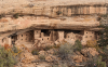
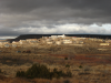
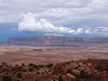
The Lukachukai Mountains are a mountain range in northeastern Arizona that lay entirely within the Navajo Reservation. The highest point of the range is an unnamed point at 9,466 feet above sea level. The mountains are still largely used as summer ranges for sheepherding. For that reason, the range is called Shíík'eh (A Summer Place) in Navajo. In Navajo mythology, this mountain range, along with the Carrizo Mountains, forms a prone male figure called Yódí Dziil (Wealth Mountain). Ch'óshgai (Chuska Mountains) forms the head; Leezhch'iih Deezgai (western Lukachukai Mountains) forms the chest, abdominal areas, and limbs; and Dzi Náhoodziii (Carrizo Mountains) forms the feet.

Mesa Verde National Park, Colorado

A national park located in southwestern Colorado covering a broad cultural landscape that includes numerous prehistoric cliff dwellings.In 1906, President Theodore Roosevelt designated Mesa Verde National Park to protect what was considered one of the largest and best-preserved archaeological sites in the world. In 1978, Mesa Verde was also designated as a protected UNESCO World Heritage site.

The prehistory of Mesa Verde reaches back to around 550 CE, when Basketmaker people built subterranean pit houses on the top of Mesa Verde’s large sandstone plateaus and grew corn. By 750 CE, the occupants of this region began to build pueblos with room blocks and ceremonial kivas above ground. Finally, around 1150-1200 CE, the Ancestral Puebloans began constructing large multi-story dwellings within deep alcoves on the sides of the mesas, which had been created by water erosion. The alcoves chosen for occupation were generally on the south-facing side of the mesas in order to take advantage of as much seasonal passive solar heating and cooling as possible. The most famous of these cliff dwellings is Cliff Palace, a 200-room, multi-story pueblo ruin located in the Great Mesa. These dwellings were occupied until 1300 CE when a drought drove the people out of the region.

Many Ruins Canyon, Arizona

Also known as Chinle Wash, Many Ruins Canyon is the repository for the various tributaries of Canyon de Chelly in northeastern Arizona. The red sandstone walls intermittently break into the ledged cliff-dwellings that give the canyon its name. These early sites were abandoned around 1400 CE as part of the mysterious mass disappearance of the peoples who had inhabited the extensive network of cliff dwellings found throughout the Southwest. The Navajo began to settle in and around the canyon during the eighteenth century, pushed westward by Spanish settlement along the Rio Grande and rising antagonisms with the Comanche and Ute tribes to the north and east. Decades of violent struggle for control of the area culminated as Kit Carson brutally implemented the United States’ Navajo removal policy in 1864, when Carson and his troops forced thousands of Navajo to march in the "Long Walk" from Canyon de Chelly to incarceration on a "reservation" at Bosque Redondo. Hundreds, if not thousands, of Navajo died due to starvation, exposure, and illness along the way and during their forced internment. In 1868, Canyon de Chelly, Many Ruins Canyon, and other portions of Navajo Country were returned to the Navajo.

Laguna Pueblo, New Mexico

The Laguna Pueblo of central New Mexico consists of six major villages, of which the political center is Old Laguna (Kawaika) on a knoll above the San Jose River about 42 miles west of Albuquerque on U.S. Route 66/Interstate-40.

Although each Pueblo community is unique, Pueblos along the Rio Grande in New Mexico all share some common characteristics. From architecture to spiritual observances, Pueblo life consists of an integration of nature, spirit, and material in a synthesis that looks toward the holistic well-being not just of the community but also the universe in which it exists.

Klethla Valley, Arizona

Klethla Valley is located in the Four Corners region of Arizona on the Navajo Nation between Black Mesa to the south, and Shonto Plateau to the north. This 10-mile long valley is also known as Klethlana Valley.

Klagetoh, Arizona

A small town in Apache County, Arizona, located in northeast Arizona along U.S. Route 191. The Navajo name for this place is Łeeyi’tó, meaning "water in the ground." In the 1920’s, a trading post was opened there. However, by 1970s the trading post had closed. Today, Klagetoh consists of its extended community, a chapter house, and a day school.

King Ranch, Texas

One of the largest ranches in the world, this cattle ranch is located in South Texas and was founded in 1853 by Richard King. It is 825,000 acres and was named a National Historic Landmark in 1961.

Kam Bimghi Valley, Arizona

Kam Bimghi, also spelled Kah Bihgi, Valley is located in Apache County, Arizona. It is also known as Red Rock Valley and has sandstone buttes, spires, and arches that are comparable to those of Monument Valley, some 50 miles to the northeast. The community primarily clusters around Cove Trading Post, which lies on the northeastern slopes of the Lukachukai Mountains.

Kayenta, Arizona

Kayenta, a small town in Navajo Country, AZ, sits at the intersection of US Highways 160 (formerly Navajo Route 1) and 163 on the Navajo Nation, about 25 miles south of the iconic Monument Valley. The community was home to an early day school, a tuberculosis sanatorium that became an Indian Health Service hospital, and several trading posts. The Navajo call this community "Tó Dinéeeshzhee,” which means "Fringed Water" or "Fingers of Water." There have also been several archaeological digs and explorations based out of Kayenta.

Kaibito Plateau, Arizona

The name Kaibito Plateau comes from the Navajo word "K'ai'bii'Tó," which means "spring in the willows." The plateau lies between Page and Tuba City, Arizona. A request to the Navajo Nation must be given in order to access the plateau.

Pages

Subscribe to RSS - Geographic Reference