Geographic Reference

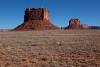
Navajo Reservation, Arizona, Utah and New Mexico

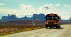
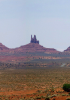
Also referred to colloquially as "the rez," the Navajo Reservation covers 27,425 square miles of territory and includes portions of northeastern Arizona, southeastern Utah, and northwestern New Mexico. It is the largest land area governed by a Native American sovereign nation in the U.S.. Similar to other areas "reserved" for indigenous Americans, the Navajo Reservation is comprised of a complex interweaving of ongoing negotiations between what it means to embody traditional and contemporary iterations of Native America, especially when Native and non-Native value systems collide in often violent, and sometimes complementary, fashion on, at the borders of, and near the reservation.

Navajo Mountain, Arizona & Utah

Also known as “Naatsis’áán” in Diné. A dome-shaped mountain (elevation 10,388 ft) that straddles the Utah-Arizona border, with its highest peak on the Utah side. It is the easiest landmark to spot in western Navajo country and is considered sacred by local indigenous groups including the Navajo, the Paiute, and the Hopi. In the Navajo tradition, the mountain represents the head of the female corn pollen spirit, Earth Woman. The mountain also features prominently in the Navajo Coyoteway story.

While Navajo Mountain is not one of the four sacred mountains of the Navajo origin story, it is believed to be a mountain that emerged after the creation of the earth due to its own powers, which include curing sickness and bringing rain. Because of the mountain's location on a border and near the Rainbow Bridge, another important feature in the Navajo origin story, the mountain served as a peaceful meeting ground between the Navajo and Paiute. While many areas surrounding Navajo Mountain are available for hiking and camping as part of the Navajo Nation Tribal Park, because of the sacredness of the mountain, climbing and summiting the peak are forbidden.

Natani Tso, Arizona

Also spelled Naat'áanii Tsoh, Natani Tso, meaning "Big Leader” in Navajo, is an iconic volcanic plug, or lava butte, northwest of Kam Bimghi (Chinle) Valley in northeast Arizona. This geologic feature is also known as King-on-His-Throne and is located within Monument Valley State Park in Utah, which itself is on the Navajo Tribal Reservation.

Moenkopi Plateau, Arizona

The Moenkopi Plateau is located to the west and southwest of the Hopi Mesas in north-central Arizona. Near the communities of Tuba City and Moenkopi, this vast plateau is comprised of flat, sandy, and fairly barren terrain broken by canyon systems filled with colorful rock formations and hoodoos of eroded sandstone. The area is used by both the Hopi and Navajo to graze livestock.

Moenkopi, Arizona

Moenkopi, in northeastern Arizona, is a Hopi cultural stronghold embedded within the Navajo Reservation. Moenkopi has been an agricultural center for the Hopi people since the thirteenth century, a "suburb" pueblo to the village of Oraibi on Third Mesa on the Hopi Reservation, one of the oldest continuously inhabited pueblos on the continent. Because of Moenkopi's relative isolation from the rest of Hopi lands, it has been subjected to intensive outside influence, and, as a result, has split into two factions: Lower Moenkopi, the more traditional community interested in mainting traditional social and cultural practices, and Upper Moenkopi, the "younger" community interested in pursuing modern pursuits.

Ha'wi-k'uh, New Mexico

Ha'wi-k'uh, the ancestral village of the Zuni founded in the 1400s, was the largest of the Zuni pueblos, and the first pueblo to be seen by Spanish explorers. Originally thought to be one of the fabled gold Cities of Cíbola, Ha'wi-k'uh was conquered by Coronado in 1540 and served as his headquarters for several months. Ha'wi-k'uh was permanently abandoned after the 1680 Pueblo Revolt. In its prime, Ha'wi-k'uh had up to 150 rooms surrounding a central plaza and stood four stories high, with multiple numbers of kivas and a population between 500 to 700 individuals. Although Ha'wi-k'uh is now a series of ruins that run along a ridge several miles south of the current thriving pueblo, it remains an important cultural site for the Zuni and is an integral component in many of their migration and origin stories, ceremonies, and prayers.

The ruins of Ha'wi-k'uh were designated a National Historic Landmark in 1961.

McKinley County, New Mexico

McKinley County is located in the northwest portion of the state of New Mexico atop the San Juan Plateau. It was created in February 1899 and named for William McKinley, the 25th president of the United States. The county seat is Gallup, the county's largest town, which is also the center of the American Indian Inter-tribal Ceremonial that occurs every August. Portions of the Zuni and Navajo Nation Reservations lay within the county's boundary. McKinley County economy is driven by lumber industry, oil refining, coal mining, and uranium production.

Maryland

A small state located in the east-central coast of the United States of America, named after the wife of the British King Charles I. This state was one of the original 13 colonies and was incorporated in 1632. After the American Revolution, Maryland became a state on April 28, 1788.

During the American Civil War Maryland remained a neutral border state between the Union and the Confederacy, as its population was split between those who supported the North and those who supported the South. It was the location for an important battle during this war, the Battle of Antietam, which ended in a stalemate. After the Battle of Antietam, President Abraham Lincoln issued the Emancipation Proclamation, which declared the manumission, or freedom, of African American slaves in the U.S., even though the decree was not legally binding until the 13th Amendment to the U.S. Constitution was passed in 1865.

Many Farms, Arizona

Also known as Da’ah’eh Halani in Navajo, Many Farms is a small, primarily Navajo community about 15 miles north of Chinle, with a trading post, chapter house, and historic agricultural foundation. Although the community pre-existed the confluence of US Highway 191 and Navajo Route 59, it was only after 1937 and the damming of Sheep Dip Creek to create Many Farms Lake that the community began to develop in terms of emerging infrastructure.

Los Gigantes Buttes, Arizona

This geologic feature consists of large, craggy, sandstone buttes located almost midway between Chinle and Lukachukai on the Navajo Reservation in Apache County in northeast Arizona. The Navajos call this place Tsé Ch’deelzhah, which means “rocks jut out.”

Pages

Subscribe to RSS - Geographic Reference